I. The Brookshire Neighborhood
In 1967 the Hughey Construction Company bought the Talges/Block Farm consisting of approximately 380 acres of farmland straddling both sides of Cool Creek between 116th and 126th Streets west of Grey Road, with plans to build a revolutionary golf course and neighborhood. Hughey’s co-owner Oliver Hughey was a fan of old English lore and came up with the idea of calling the neighborhood Brookshire and naming all the streets old English names. It was also his idea to build the famous lions gates.
Hughey hired local landscape architect Gary Kern of Weihe Engineering to develop the neighborhood. It was Kern’s idea to build wide, curving streets and multiple cul-de-sacs and to build within the existing topography rather than bulldozing to level the land.
The Brookshire neighborhood was developed in seven separate phases. Phase 1 occurred in 1970 and consisted of the north end of Brookshire Parkway and Windsor Drive. Phase 2, also developed in 1970, included the south part of Brookshire Parkway to Grey Road. Phase 3, developed in 1971, consisted of the south part of Windsor Drive and Castle Row Overlook. Phase 4, also developed in 1971, included Somerset Way East, Royal Oak Lane, and Buckingham Court. Phase 5, developed in 1972, consisted of Somerset Way South. Phase 6A, developed in 1973, included Carmel Drive, Coventry Way, 126th Street, and Royce Court. Phase 6B, also developed in 1973, consisted of Crestwood Drive. Most homes were built between 1972 and 1980, but the rumor is at least one structure survived from the past—a smokehouse on Somerset Way South.
Brookshire’s most famous resident is Wayne Gretzky, who, while briefly playing for the Indianapolis Racers in 1978 and taking classes at Broad Ripple High School, lived with a host family in Brookshire. Said Gretzky when revisiting Indianapolis in 2018, “I lived with a family in Carmel, they were wonderful to me, treated me like one of their own children. It was the most comfortable part of being here.” Typical Brookshire!
II. The Brookshire Golf Course and Clubhouse
Hughey hired local resident and golf course architect Bill Diddel to design the Brookshire golf course. Diddel was a resident of the Woodland neighborhood and designed the Woodland Country Club golf course. His idea was to develop the Brookshire golf course largely within the Cool Creek flood plain so as to not disrupt the developing Brookshire neighborhood and to provide the homes with spectacular views of the course.
The development was called the Brookshire Golf & Country Club, which was established as a private club separate from the neighborhood. The original plan called for a top-notch golf course, a swimming pool, and a large clubhouse with a helipad and a large tree-lined pedestrian walkway leading from Grey Road to the clubhouse entrance. The plan was eventually scaled down and a smaller clubhouse was built with no helipad nor pedestrian walkway ever being fully developed. However, remnants of both can still be seen today. The large concrete outline of the helipad can be seen just to the left of the golf course entrance. The pedestrian walkway, which was to be built on the land situated between 4427 Camelot Lane and 12115 Brookshire Parkway across the street from the golf course entrance is still an undeveloped narrow strip of land today. This privately-owned strip of land is now a dead end—being cut off from Grey Road by the later development of Brookshire Village.
The golf course officially opened for play on June 25, 1971.
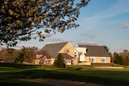
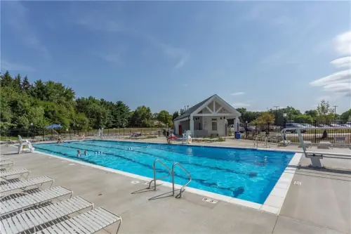
Due to financial strains, in 2006 the Brookshire Golf Course & Country Club owner and its lender began exploring the idea of selling the property for the development of additional homes or even condominiums. Neighbors vehemently opposed the plan. The City of Carmel stepped in and instead purchased the golf course and clubhouse with the intent of making it Carmel’s first and only public golf course. (As discussed below, the City did not acquire the swimming pool until 2013.) In 2019 the City of Carmel completed a series of upgrades to the property, including improvements to the golf course, cart paths, and irrigation system, and the building of a new 20,437-square-foot clubhouse, a 605-square-foot pool house, and a 4-lane 25-meter swimming pool.
III. The Brookshire Pool
The Brookshire Golf Course & Country Club development always included a pool, which has a complicated (but ultimately successful) history with the Brookshire neighborhood. In 1999 the owners decided they no longer wanted to operate a pool that was continually losing money and intended to close it. Instead, four to five families, who were all either living within or just outside the Brookshire neighborhood, established the not-for-profit Brookshire Swim Club, Inc., which, while not owning the pool, agreed to manage it financially independent from the golf course and clubhouse. In 2006 the Brookshire Swim Club purchased the pool outright when the golf course and clubhouse were sold to the City of Carmel, which chose to pass on buying the pool. In 2013 the City of Carmel changed course (no pun intended) and agreed to purchase the swimming pool—putting the Brookshire golf course, clubhouse, and swimming pool under single ownership for the first time since 2006.
The next year, 2014, the City of Carmel began leasing the swimming pool to the Brookshire HOA, which managed it for the benefit of the City of Carmel, Brookshire, and surrounding neighborhoods. In 2020 the City of Carmel agreed to sell the pool to the newly-formed not-for-profit Brookshire Water Safety and Education, Inc. (BWSE), which was established solely to own and operate the pool for the benefit of Brookshire and surrounding neighborhoods. Although closely associated with the Brookshire HOA and thus the Brookshire neighborhood, it is financially separate from both.
The Brookshire pool has survived 20 years of complicated transactions, the building of the Monon Center swimming facilities, and COVID-19, and today is thriving like no other time in its history. The purchase agreement with the City of Carmel requires BWSE to operate the pool for the next 99 years with memberships open to the public. In other words, the Brookshire Pool is here to stay!
IV. Earlier Settlements and Farms
The Brookshire neighborhood was developed in 1969 on land that was originally inhabited by the Delaware tribe. In 1840 one of the area’s earliest settlers, William Wilkinson established a mill along the south side of Cool Creek (the current 15th hole fairway). The Wilkinson Mill was accessed by a primitive road just to the west of the mill that became known as Wilkinson Road (which south of 116th Street later became Haverstick.) Wilkinson Road soon thereafter became a part of the Noblesville-Indianapolis County Road, an important thoroughfare that ran from Indianapolis to Noblesville through the east side of Carmel (including the southeast part of Brookshire) on roads that later became known as Haverstick, Cherry Tree, and River Road.
In the 1840s and 50s settlers began establishing homes and small shops near the Wilkinson Mill. In 1860 a settler and entrepreneur named Madison “Matt” Richardson built a two-story framed house and general store on northwest corner of the intersection of 116 th Street and Wilkinson Road. The original Richardson House still stands today with some additions on the north side of 116th Street where it tees with Haverstick. In 1869 Hamilton County built a bridge over The White River on 116th Street, which greatly increased traffic in the area and led to further developments. In 1877 the Mattsville Post Office was established in the Richardson House/General Store, giving the area the name of Mattsville, named after Richardson’s nickname “Matt.” In 1893 Richardson died, and in 1902 the post office was moved to a location closer to Rangeline Road, thus beginning the decline of the Mattsville General Store and the Town of Mattsville itself.
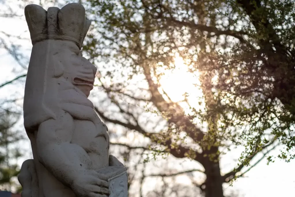
In 1923 Indianapolis Industrialist John Talge and his wife Marion purchased approximately 380 acres of land (the land that would become Brookshire 46 years later) for use as a hobby farm—popular with the Indianapolis elite at the time. The Talges called their farm The Indian Mound Farm. It became famous for its display of a large Indian statue, dedicated in 1924, which stood on the highest point of the property (near the current Grey Road entrances). While digging a trench to run a gas line to the statue, Indian bones were discovered—hence the name The Indian Mound Farm.
In 1941 the Talges sold the land to Meier Block of the Block’s Department Store fame, who continued to use the land as a hobby farm—growing mostly corn and soybean, but also raising cattle, pigs, and chickens. He called his farm The Cool Valley Farm. Shortly after purchasing the land, he built a summer mansion on a small bluff overlooking Cool Creek a few hundred feet south of 126th Street (near the high point on current Windsor Drive). By the mid-1960s, the mansion had been abandoned, fell into disrepair, and eventually burned to the ground. A separate farmhouse and barn sat on the west side of Cool Creek about a quarter mile south of 126 th Street (off the current Carmel Drive, which, at the time, was merely a long gravel driveway leading from 126th Street to the farmhouse and barn.) The farmhouse was occupied by long time Carmel resident Paul Owens and his family. Owens managed the farm for Meier Block for many years after having previously managed the larger 527-acre Lynwood Farm bounded by 116 th Street to the south, Hazel Dell Parkway to the west, 131 st Street to the north, and River Road to the east.
In 1967 Meier Block died and his heirs made the decision to sell the property, which ultimately led to Hughey Construction Company’s purchase and development of Brookshire.
– Jim Dawson, Brookshire HOA Board Member, 2024